Figure 1: Claim Overview Map for Georgia River
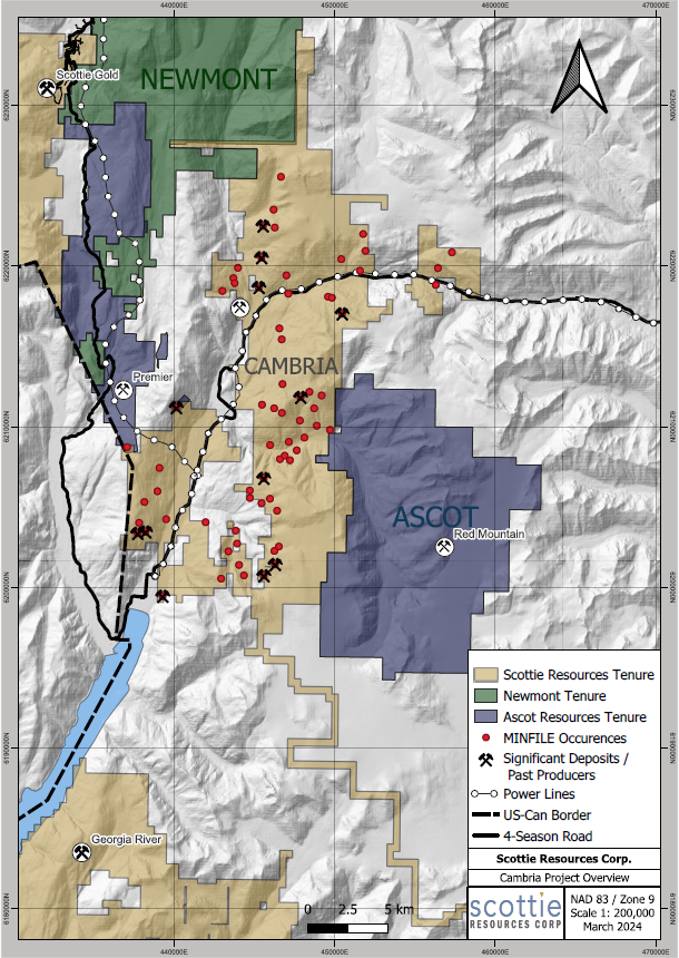
The Cambria Project is situated just outside of Stewart, BC on the western edges of the Cambria and Todd Icefields. Scottie Resources Corp. has nearly 100% ownership in the 31,736 ha project, which consists of 140 mineral claims. The Project is bordered to the north by Newcrest Mining’s Brucejack Mine, to the west by Ascot Resources’ Premier Gold Project and to the east by Ascot Resources’ Red Mountain Project.
The Project is underlain by late Triassic Stuhini Group sediments, and Early to Middle Jurassic volcanics and associated volcano-sedimentary units which are intruded by Early Jurassic and Eocene age intrusions. These rocks host a variety of significant precious and base metal deposits elsewhere in the Stewart Camp including the Granduc, Silbak-Premier, Silver Coin, KSM, Brucejack, Scottie-Gold, and Red Mountain deposits. Mineralization on the property generally consists of high-grade Ag-Zn-Pb ± Au-Cu polymetallic veins.
Project Highlights
- Project boundary is within 1km of the town of Stewart, BC with portions of the project being road accessible
- Rapid glacial retreat has exposed new targets to investigate
- 83 MINFILE mineral occurrences are located on the Cambria Project including five small historic high-grade silver-lead-zinc-+/-gold past producers
- The northern portion of the Project encompasses the Red Cliff – Montrose trend, a 2 kilometre long by 30- to 40-metre-wide mineralized zone. Gold-bearing veins within this shear zone have been intersected over a vertical distance of approximately 700 meters. Drilling by Decade Resources along this structure has produced several high-grade gold intercepts of greater than 100 gram-metres including hole 2010-MON-28 which returned 49.2 g/t Au over 18.45 metres.
- A total of 653 rock samples and 38 soil samples were collected during the 2023 field season.
- A total of 552 rock samples and 38 soil samples were collected (Cambria, 2023)
- A total of 101 rock samples were collected (Enterprise, 2023)