
[ News Release ]
Scottie Resources Launches Major 2026 Growth Campaign with 50,000 Metre Drill Program at Scottie Gold Mine Project
May 21, 2026
Scottie Resources Launches Major 2026
Growth Campaign with 50,000 Metre Drill
Program at Scottie Gold Mine Project
Join Management for a WEBINAR to discuss These Plans on
May 26, 2026, at 10:00am PT
Vancouver, British Columbia--(Newsfile Corp. - May 21, 2026) - Scottie Resources Corp. (TSXV:
SCOT) (OTCQB: SCTSF) (FSE: SR80) ("Scottie" or the "Company") is pleased to announce its
planned 2026 expansion focused drill program at the road-accessible Scottie Gold Mine Project
("Project"), located 35 kilometres north of Stewart in the Golden Triangle of British Columbia.
The 2026 exploration program will consist of approximately 52,000 metres of diamond drilling,
highlighted by a record 50,000 metre campaign at the Scottie Gold Mine Project and 2,000 metres at
the Cambria Property. Drilling at Scottie will run from June through October using seven drill rigs,
including four skid-mounted and three helicopter-supported drills, marking the largest program in the
Company's history. The fully integrated campaign will also include geophysical and geochemical surveys
alongside continued advancement of environmental baseline studies, now entering their final year. The
district-scale Project includes the Company's 100%-owned past-producing Scottie Gold Mine and the
adjacent Blueberry Contact Zone. Following Scottie's most successful drill season to date, the 2026
program is designed to advance priority areas across the Project through a combination of resource
conversion and expansion drilling. The infill program is aimed at upgrading Inferred resources to
Indicated, alongside step-out drilling targeting extensions of known mineralized zones and test new
targets across the broader system.
Highlights:
Fully financed $26 M exploration program
Over 50,000 metres of diamond drilling
Significant infill and expansionary drilling at the Blueberry Contact Zone
Large infill program at the Scottie Gold Mine to support resource conversion and test
extensions of known mineralized veins along strike and at depth
Continued drilling at the Bend Vein, including follow-up on a new near-surface gold zone
discovered in 2025
Exploration drilling planned at multiple targets, including:
C and D Zones
Serac Vein / Lakebed area
Domino and other regional exploration targets
Geotechnical, hydrogeological, and condemnation drilling to support infrastructure and future
development planning
Large-scale geophysical and remote sensing programs, including a 107-hectare 3D induced
polarization ("IP") survey, a seven line-kilometre magnetotelluric ("MT") survey, and a 290 km²
airborne LiDAR and orthophoto survey
Expanded environmental baseline and technical studies, now entering their second year,
including hydrology, hydrogeology, fisheries and aquatic resources, wildlife and habitat, vegetation
and wetlands, climate and meteorology, geochemistry, and archaeological programs
First-ever drill program planned at the Cambria Property, consisting of approximately 2,000
metres of drilling
"The scale and scope of our 2026 program reflect the growing confidence we have in the potential of
the Scottie Gold Mine Project," said Thomas Mumford, President & CEO. "Following our strongest
drill season to date, we are aggressively advancing both resource growth and development initiatives
across the district. With a fully funded program and drilling planned across several high-priority
targets, we believe 2026 has the potential to be a transformational year for Scottie as we move toward
a Feasibility Study."
WEBINAR
Join Scottie Resources management for a live online seminar reviewing the Company's strongest
exploration season to date, including key 2025 drilling results, bulk sample progress, and the record-
scale 2026 exploration program at the Scottie Gold Mine Project in British Columbia's Golden Triangle.
Date: May 26, 2026
Time: 10:00am PT
Where: https://6ix.com/event/scottie-resources-annual-program-review-and-next-steps
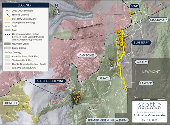
Figure 1: Overview plan view map of the Scottie Gold Mine Project depicting targets with existing
resources (dark blue labels) and regional target locations (light grey labels).
To view an enhanced version of this graphic, please visit:
https://images.newsfilecorp.com/files/11118/298334_c03d238714754b7b_002full.jpg
2026 EXPLORATION PROGRAM – SCOTTIE GOLD MINE PROJECT
Most of the drilling in 2026 will be focused on the Blueberry Contact Zone, where previous drilling has
demonstrated strong continuity of high-grade gold mineralization across multiple vein corridors.
Blueberry forms a principal component of the development concept outlined in the Company's
Preliminary Economic Assessment, including the Direct-Ship Ore ("DSO") scenario, which
contemplates initial production from a shallow open pit followed by underground mining.
Drilling at Blueberry will consist of a large infill and expansion program designed to further improve
confidence in the continuity and geometry of mineralization and support expansion of the resource.
Targeted step-out drilling will also evaluate extensions of the system at depth below the Blueberry
Contact Zone and along strike to the south toward the Gulley Zone.
A significant portion of the 2026 program will also be directed toward the Scottie Gold Mine. At the
historic mine, drilling will focus on a large infill program predominantly within the L, M, and N Zones to
support resource conversion, while also testing extensions of known high-grade mineralization both
along strike and at depth. Additional drilling will also target down-plunge and along strike extensions of
the O Zone within an undrilled portion of the system.
The 2026 program will include drilling at the Bend Vein, where 4 to 5 holes are planned to continue
testing and expanding mineralized structures associated with this near-surface vein system. The Bend
Vein was the source of the Company's 2025 bulk sample, which provided a demonstration of mining and
processing under a DSO scenario and generated approximately $7.5 million in revenue. Drilling during
the 2025 program also identified additional near-surface mineralization, including the discovery of a new
vein, which will be followed up during the 2026 program.
Exploration drilling is planned across multiple target areas, including the Serac Vein / Lakebed area,
located south of the Blueberry Contact Zone. A total of 3 to 4 holes is planned to follow up on previous
vein intersections and evaluate the southern extent of the mineralized system. Additional exploration
holes are planned at the C and D Zones, where previous drilling has identified multiple high-grade
mineralized structures. The 2026 program will continue to test and expand these structures while
evaluating their continuity at depth and along strike.
A portion of the 2026 program will be dedicated to testing emerging and underexplored targets across
the property, including Domino, located on the western side of the property. Domino shares key
geological characteristics with the Blueberry Contact Zone and other high-grade zones across the
Project and is interpreted to form part of the broader mineralized system. Drilling at Domino will consist
of 10 to 15 holes designed to test mapped vein structures, deeper geophysical targets, and areas of
high-grade surface samples. Additional regional exploration drilling will also target project-wide
prospective areas identified through previous geophysical surveys, geological mapping, and surface
sampling programs. These targets provide opportunities to identify additional zones of high-grade
mineralization and further demonstrate the district-scale potential of the Scottie Gold Mine Project.
GEOPHYSICS AND REMOTE SENSING
Scottie will complete geophysical work across priority areas of the property as part of the 2026 program,
including a 107-hectare 3D distributed-array induced polarization ("3DIP") survey and a seven line-
kilometre magnetotelluric ("MT") survey. The 3DIP program will utilize a DIAS32 distributed-array system
with common voltage referencing (CVR), designed to generate a high-density 3D dataset of
chargeability and resistivity. The survey is designed to image chargeability and resistivity distributions to
depths exceeding approximately 400 metres and will support identification of sulphide-associated
mineralization and structural controls across key target areas.
The DIAS32 distributed-array system is expected to provide substantially greater data density and
improved multi-azimuth coverage relative to conventional IP surveys, enhancing the Company's ability to
model lithological contacts, fault systems, alteration corridors, and potential feeder structures associated
with high-grade gold mineralization across the Project. The resulting inversion models will be integrated
with geological mapping, drilling, structural interpretation, and geochemical datasets to refine targeting.
In addition, Scottie plans to complete an MT survey across up to 15 priority and 14 secondary stations,
covering approximately seven line-kilometres across the Project from the Blueberry Contact Zone to
Domino. The MT survey will use naturally occurring electromagnetic fields across a broad frequency
spectrum to model deep subsurface resistivity contrasts and large-scale structural features potentially
associated with mineralization controls beneath the Project area. The MT dataset is expected to
complement the higher-resolution 3DIP survey and provide insight into deep structural architecture,
intrusive centres, major fault systems, and fluid pathways across the broader mineralized system.
Scottie also plans to complete a helicopter-borne LiDAR and orthophoto survey covering approximately
290 km² across the Project. The survey will use a Phoenix Ranger XL (Riegl VUX 240) LiDAR system
and PhaseOne imaging camera to acquire high-resolution topographic and orthophoto datasets at
planned raw point densities of approximately 20 to 50 points per square metre and image resolutions of
up to 5 cm GSD.
The airborne survey is designed to generate detailed digital terrain and surface models capable of
penetrating vegetation and forest canopy cover to improve geological and structural interpretation
across the Project area. Deliverables are expected to include high-density georeferenced point cloud
datasets, digital terrain models ("DTMs"), digital surface models ("DSMs"), vegetation classification
products, and orthophoto mosaics to support geological mapping, structural interpretation, drill targeting,
infrastructure siting, hydrological assessments, geotechnical studies, and environmental baseline
programs.
The Company believes the LiDAR dataset will significantly enhance interpretation of subtle structural
lineaments, glacial geomorphology, drainage features, historical disturbances, and topographic controls
on mineralization while also supporting future engineering, mine planning, and development activities
across the Project area.
In addition to drilling and geophysics, Scottie will undertake targeted geochemical surveying consisting
of surface rock sampling to further define known mineralized trends and support the identification of new
areas of interest across underexplored portions of the property.
ENVIRONMENTAL AND TECHNICAL STUDIES
In parallel with exploration, Scottie will continue to advance its environmental baseline work, building on
data collected during the 2025 field season. Baseline studies completed to date have established
datasets across key disciplines, including hydrology, hydrogeology, fisheries and aquatic resources,
wildlife and habitat, vegetation and wetlands, climate and meteorology, geochemistry, archaeology and
cultural heritage, providing a strong technical foundation for environmental characterization, engineering
studies, mine planning, and future regulatory applications.
Hydrology
Surface water quantity and quality monitoring initiated during 2025 will continue through the 2026 field
season, including ongoing hydrometric monitoring, stream flow measurements, seasonal water quality
sampling, and catchment response analysis. The work is designed to improve understanding of
watershed behaviour, seasonal flow variability, precipitation-runoff relationships, and baseline water
chemistry across the Project area. Data collected through the program will support development of a
site-wide water balance model and integrated water management strategy for future project planning.
Hydrogeology
Hydrogeological investigations and groundwater monitoring programs initiated in 2025 will continue
throughout 2026 to further characterize groundwater flow regimes, hydraulic connectivity, groundwater
quality, and interactions between surface water and groundwater systems. Work will include continued
groundwater level monitoring, hydrogeological modelling, and development of a hydrogeological
conceptual model for the Project. The program is intended to support future mine design, underground
development planning, and water management infrastructure design.
Fisheries and Aquatic Resources
Aquatic baseline studies initiated during 2025 will continue across key watercourses and aquatic
habitats throughout the Project area. Programs are designed to characterize fish habitat conditions,
aquatic productivity, species presence, and seasonal habitat utilization. Fieldwork completed to date
has included aquatic habitat assessments, fisheries inventories, and baseline aquatic monitoring
programs intended to support future environmental planning and regulatory review.
Wildlife and Habitat
Wildlife baseline studies completed during 2025 included deployment of remote wildlife cameras and
Autonomous Recording Units ("ARUs") for bat, bird, and amphibian monitoring, as well as aerial and
ground-based wildlife surveys. Preliminary field programs documented numerous wildlife species across
the Project area, including species of management interest such as wolverine and mountain goat. The
2026 program will significantly expand seasonal wildlife surveys through multiple field campaigns
focused on breeding, migration, overwintering, and habitat utilization patterns across the Project area.
Planned work includes aerial ungulate surveys, raptor monitoring, bat acoustic monitoring, bird point
counts, amphibian surveys, and continued remote camera and ARU monitoring programs.
Vegetation and Wetlands
Vegetation and wetland baseline programs initiated during 2025 will continue in 2026 through
ecosystem mapping, wetland delineation, rare plant assessments, and habitat characterization studies.
The work is intended to support infrastructure planning, habitat characterization, and reclamation and
closure planning across proposed disturbance areas.
Climate and Meteorology
Scottie initiated climate and meteorological monitoring during 2025 through installation of an on-site
meteorological station to support collection of baseline climatic data, including precipitation,
temperature, and seasonal weather patterns. Continued climate monitoring during 2026 will support
hydrological modelling, infrastructure design criteria, water management planning, and long-term
environmental characterization of the Project area.
Geochemistry
Scottie will continue advancing geochemical characterization and metal leaching and acid rock drainage
("ML/ARD") studies at the Scottie Gold Mine Project in 2026 as part of an integrated baseline
geochemistry program supporting mine planning, environmental baseline studies, and future permit
amendment activities. The 2026 program represents a continuation and expansion of geochemical work
initiated in previous years focused on both legacy mine materials and proposed future mine plan
materials.
In 2025, Scottie completed preliminary geochemical characterization programs on materials
representative of potential construction borrow sources, waste rock, pit wall rock, underground
development materials, and legacy mine materials. A total of 103 drill core samples were collected and
submitted for geochemical characterization to support assessment of long-term geochemical behaviour
and residual ML/ARD risks associated with proposed mine development and reclamation planning.
The 2026 baseline geochemistry program will include continued characterization of waste rock,
construction borrow materials, ore sorter waste, and other mine-related materials through a combination
of static testing, short-term leachate extraction testing, mineralogical analysis, particle size analysis,
laboratory kinetic testing, and field kinetic testing. Planned laboratory programs include Acid-Base
Accounting, Net Acid Generation testing, whole rock analysis, humidity cell testing, subaqueous column
testing, and Shake Flask Extraction testing designed to further evaluate long-term geochemical
behaviour, sulphide oxidation potential, constituent release rates, and residual ML/ARD risks associated
with mine materials.
Field kinetic testing programs planned for 2026 include Field Leach Barrel testing designed to evaluate
geochemical behaviour under site-specific climatic and hydrological conditions, including seasonal
wetting and flushing cycles. The Company believes these studies will provide important inputs for water
quality modelling, source term development, mine waste management strategies, and long-term
reclamation and closure planning.
The geochemistry program will also support development of a draft ML/ARD Management Plan and
ongoing collaboration between geochemistry, mine planning, hydrogeology, environmental baseline, and
water quality modelling teams. Results from the program are expected to support waste and contact
water management strategies, and future infrastructure and mine development planning.
Archaeology and Cultural Heritage
Scottie has also advanced archaeological and cultural heritage initiatives associated with the Project.
During 2025, an Archaeological Overview Assessment was completed for the broader Project area,
identifying areas of elevated archaeological potential associated with hydrological features and
historical land-use corridors. The Company has subsequently submitted a Section 12.2 Heritage
Inspection Permit application to support Preliminary Field Reconnaissance and future Archaeological
Impact Assessment work in consultation with Indigenous groups and regulators. Planned archaeological
programs are expected to include pedestrian surveys and subsurface investigations across priority
development and infrastructure areas.
The Company continues to advance technical work and environmental studies in support of future
permitting and development planning, following the determination that the Project is below provincial and
federal environmental assessment thresholds, allowing it to proceed through the provincial permitting
process toward a Joint Major Mine Permit Application.
CAMBRIA AND GEORGIA RIVER PROPERTIES
In addition to activities at the Scottie Gold Mine Project, the Company plans to initiate its first-ever drill
program at the Cambria Property during the 2026 field season. The program is expected to comprise
approximately 2,000 metres of diamond drilling between July and August.
The Cambria Property is a large, district-scale land package covering approximately 28,000 hectares
across 120 mineral claims, located between the Premier Mine and Red Mountain deposit in the Golden
Triangle. The property hosts 83 documented mineral occurrences, including five historical mines, and
remains underexplored relative to its size and geological setting. The property is situated within an area
of ongoing exploration and development activity, with nearby projects advancing toward production and
the development of supporting infrastructure in the region.
Exploration by Scottie over the past five years has focused on geological mapping and geochemical
sampling, which has identified numerous prospective targets across the property. The planned 2026 drill
program represents the first opportunity to evaluate these targets at depth and marks a key step in
advancing the broader potential of the Cambria Property.
Additional fieldwork is also planned on the Georgia River Project, which hosts the past-producing
Georgia River Mine, with a focus on the central and eastern portions of the property. The program will
build on earlier work that has outlined high-grade mineralization and multiple prospective targets,
supporting continued evaluation of this underexplored portion of the Project.
QUALIFIED PERSON
Dr. Thomas Mumford, P.Geo., President of the Company, is non-independent and a qualified person
under National Instrument 43-101, has reviewed and approved the technical information contained in this
news release on behalf of the Company.
ABOUT SCOTTIE RESOURCES CORP.
Scottie Resources holds 100% interest in the Scottie Gold Mine Property, which includes the high-grade,
past-producing Scottie Gold Mine and the adjacent Blueberry Contact Zone. The Company also owns a
100% interest in the Georgia Project, host to the past-producing Georgia River Mine, as well as the
Cambria, Sulu, and Tide North properties. In total, Scottie controls approximately 58,500 hectares of
highly prospective mineral claims within the Stewart Mining Camp in British Columbia's Golden Triangle
—one of the world's most prolific mineralized districts.
Scottie's current resource estimate on the Scottie Gold Mine Project includes a total of 703,000 gold
ounces at an average grade of 6.1 g/t (Inferred category) in 3.6 million tonnes, highlighting the
development potential for a significant near-surface, high-grade deposit. The Company's strategy is to
continue expanding this resource and to define additional mineralization around past-producing mines
through systematic drilling and surface exploration.
The Company has recently completed a PEA for the Scottie Gold Mine. The PEA outlines a robust
Direct-Ship Ore (DSO) development scenario with strong economics and significant upside through a
potential toll-milling option utilizing excess capacity at the nearby Premier mill. The base case DSO
project delivers an after-tax NPV(5%) of $215.8-$668.3 million at gold prices of US$2,600-$4,200/oz,
respectively. Under the toll-milling scenario, project economics improve substantially, with an after-tax
NPV(5%) of $380.1-$831.7 million (no agreement currently in place). The PEA estimates initial capital
costs of $128.6 million, average annual production of ~65,400 oz gold over seven years, and a payback
period of 1.7 years for the after-tax DSO case-reduced to just 0.9 years under the toll-milling opportunity
at US$2,600/oz.
Additional Information
Brad Rourke
Executive Chairman
+1 250 877 9902
brad@scottieresources.com
Forward-Looking Statements
This news release may contain forward-looking statements. Forward-looking statements are statements
that are not historical facts and are generally, but not always, identified by the words "expects", "plans",
"anticipates", "believes", "intends", "estimates", "projects", "potential" and similar expressions, or that
events or conditions "will", "would", "may", "could" or "should" occur. Although the Company believes the
expectations expressed in such forward-looking statements are based on reasonable assumptions,
such statements are not guarantees of future performance and actual results may differ materially from
those in forward looking statements. Forward-looking statements are based on the beliefs, estimates
and opinions of the Company's management on the date such statements were made. The Company
expressly disclaims any intention or obligation to update or revise any forward-looking statements
whether as a result of new information, future events or otherwise.
Neither TSX Venture Exchange nor its Regulation Services Provider (as that term is defined in
the policies of TSX Venture Exchange) accepts responsibility for the adequacy of accuracy of
this release.
To view the source version of this press release, please visit
https://www.newsfilecorp.com/release/298334